How far south freezing air will reach remains an open question, making it difficult to precisely forecast ice and snow accumulation. Where it happens, dangerous travel conditions and power outages are possible.
Winter storm watches and advisories already are in place for more than 12 million people in portions of states from New Mexico to North Carolina.
As the storm develops, forecast models will more accurately predict the freezing line and thus the type of precipitation places will experience, CNN meteorologist Brandon Miller said.
Here is what CNN meteorologists expect, where and when:
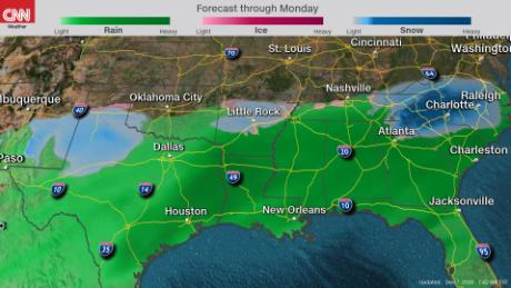
Texas and Oklahoma
Timing:Friday morning through Saturday evening
Precipitation begins with freezing rain and drizzle in the panhandles of Texas and Oklahoma and possibly into central Oklahoma. Main winter weather impacts occur late Friday, with a quick transition from a wintry mix to snow after midnight for the Texas Panhandle and West Texas and several inches of rain through Friday night across much of southeast Texas. If precipitation makes it into eastern Oklahoma, it won't turn to snow until later Saturday.
Impacts: Snow, ice and flooding rain
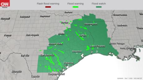
Snowfall in Texas will likely be in the 2- to 4-inch range but could reach 6 inches. Southern and eastern Texas can expect a lot of rain impacting major cities, including Dallas, Austin, San Antonio and Houston. Nearly 20 million people are under a flood or flash flood watch or warning in eastern Texas. San Antonio and Houston could see flash flooding, as rainfall total could reach 3 to 6 inches, with as much as 10 inches in isolated spots.
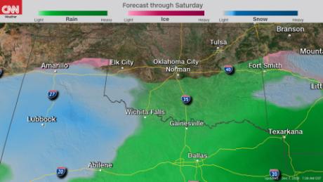
Oklahoma City may end up being on the line between dry and wet air. Still, there is a chance for some wintry weather in central Oklahoma, with snow accumulation of 1 to 4 inches and possibly one-10th of an inch of ice from Lubbock, Texas, to Oklahoma City. Tulsa, Oklahoma, will see some ice, as well as snow of 1 to 2 inches.
Arkansas and western Tennessee
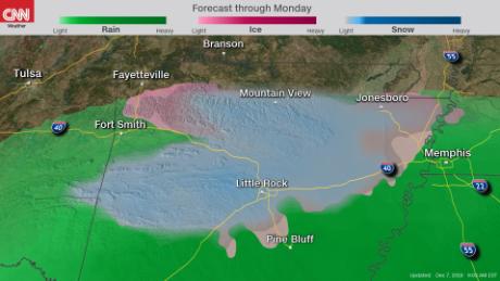
Timing: Friday afternoon through Saturday
Most Arkansans won't feel precipitation until later Friday, with winter weather beginning in the overnight hours and moving east Saturday morning toward Tennessee.
Impacts:Flooding rains, wintry mix, mountain snow
The southern half of Arkansas will get caught up in a similar situation as East Texas, with 4 to 5 inches of rain and flash flooding possible. Central Arkansas looks to only pick up, at most, 1 inch of snow. Meantime the higher elevations of the Ozark Mountains will likely see 2 to 6 inches of snow on top of a glaze of ice up to a quarter of an inch.
Snow totals will be lower in northeastern Arkansas and northwestern Tennessee, where a trace to 1 inch of snow is possible.
Eastern Tennessee, northern Georgia and the Carolinas
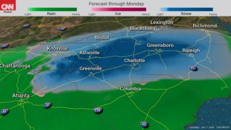
Timing: Saturday morning through Monday morning
Precipitation creeps in early Saturday, with rain in Georgia and some light, wintry precipitation in the mountains. It picks up Saturday afternoon, when blizzard conditions are possible in the higher Appalachians, with larger accumulations Sunday into early Monday morning across the zone. The storm on Monday probably will move out to sea, but it also could turn and climb up the East Coast, bringing heavy snow to major metro areas.
Impacts:Record snow, blizzard conditions, wintry mix
Significant snow is expected -- but not certain -- across the mountains of northeast Georgia and North and South Carolina. Estimates range from 1 foot to almost 2 feet in the mountains and foothills west of Interstate 85. Parts of North Carolina could see record snowfall, described by the National Weather Service called a "once-in-a-generation event." That includes Winston-Salem and Asheville, which could get a foot of snow; Raleigh, with 1 to 2 inches possible; and Charlotte. Greenville, South Carolina is likely to get 1 inch of snow.
While most forecast models keep the winter precipitation tucked into Carolinas, one shows possible freezing rain reaching down the I-85 corridor on Sunday night into Monday to Atlanta, which also could get a dusting of snow Monday afternoon.
Snow totals east of I-85 will on depend on a regional weather phenomenon called "cold-air damming" or "the wedge" -- when cold air pushes in from the northeast against the Appalachians. The mountain range acts as a dam, keeping the cold air pooled like a lake. Warmer air in this scenario would reduce snow accumulation. There's another phenomenon called a "warm nose" that would allow warmer air to mix in above the "'wedge," bringing a more wintry mix Saturday evening and overnight into Sunday morning before snow moves in northwest of I-85.
No comments:
Post a Comment